Inner Bair Island: The World No One Knew
- May 8
- 5 min read

Note: I lived in Foster City. My home was near the intersection of Foster City Boulevard and Beachpark Boulevard, across the street from Belmont Slough.
Bair Island is a 3,000 acre self-contained salt marsh bordered by Highway 101, San Francisco Bay, the community of Redwood Shores and the Port of Redwood City.
The parking area is a wide spot at the junction of 101 and East Bayshore Road. A few concrete barriers and a locked metal gate keep cars but not people off the island.


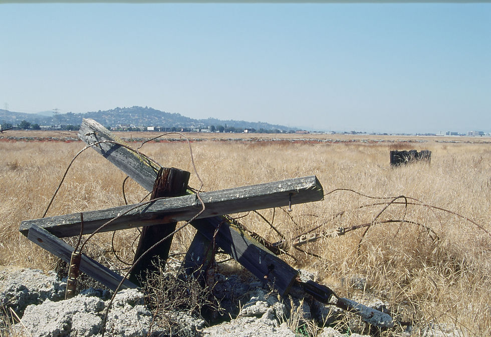
Before restoration, a wide dirt road bisected the island, with trails circling the top of the levees. People were free to explore the island’s interior although, from the vantage point of the trails, there wasn’t much to see; just flat hard-packed dirt covered with weeds, mudflats, shallow channels filled with water only at high tide, and fallen rickety remnants of wood frameworks and foundations, some over 100 years old, from small saltworks.


Until the 1940s, aside from small-scale salt harvesting, the island remained pristine tidal marsh. Between 1946 and 1952, to create salt evaporation ponds, the Leslie Salt Company built dirt levees to block the natural tidal flow from San Francisco Bay, creating sloughs that divided the island into Inner Bair—between Highway 101 and Smith Slough—Middle and Outer Bair. After 1965, the salt ponds were drained and abandoned.
In 1973, Leslie Salt sold Bair Island to Mobil Oil. In the early 1980s, Mobil Oil, Redwood City developers and politicians decided that the island—a tidal marsh between the San Andreas Fault and the East Bay’s Calaveras fault—was the ideal site to build “South Shores”with 20,000 homes, a shopping center and corporate office center. In 1982, the project was approved by the Redwood City Council, but in a citizen’s referendum, defeated by just 44 votes.
In 1989, Mobile Oil sold Bair Island to a Tokyo-based developer, Kumagai Gumi. After intense lobbying by the Friends of Redwood City, Save the Bay, the Committee to Complete the Refuge, the Audubon Society and other groups, Kumagai Gumi sold the land for $15 million to the Peninsula Open Space Trust, which then turned it over to the U.S. Fish and Wildlife Service. Bair Island is now part of the Don Edwards San Francisco Bay National Wildlife Refuge.
The Bair Island Ecological Preserve was established in 1997. In 2006, restoration began and Bair Island temporarily closed to people not involved in the project.
The work proceeded in stages. For over three years, an estimated 1,000 volunteers uprooted non-native invasive weeds and replaced them with native marsh plants.
Diking, erosion and the salt evaporation ponds had caused all three islands to subside more than two feet below what was necessary for bay sediments to support marsh plants. An estimated 1.5 million cubic yards of imported clean soil—including 300,000 cubic yards from Redwood Creek, the Port of Redwood City’s shipping channel— raised the islands to near marsh plain levels. On Middle and Inner Bair, old channels were dredged as close to their original locations as possible, and critical levees breached.
In December of 2015, on Inner Bair, the final levee was opened, allowing San Francisco Bay to flood the island.
The restored tidal sloughs, mud flats and salt marsh vegetation now provide habitat for an estimated 255 species of birds, including endangered California Clapper Rails, Western Snowy Plovers, California Least Terns and California Brown Pelicans. Endangered Salt Marsh Harvest Mice are among the 81 mammal species. Outer Bair has become a pupping site for Harbor Seals.
While Outer Bair can only be reached by kayak, canoe or airboat, and public access to Middle Bair is restricted, Inner Bair has graded trails, observation decks, a new parking lot and protective fences. Volunteers lead tours. People are free to hike, jog and bicycle.

But it’s no longer the world I knew.
In the 1990s, I freelanced as a nature photographer. Less than ten minutes from my home in Foster City, Inner Bair was among my favorite locations.
I don’t remember precisely when I discovered the hidden world, but it was probably the first time I ventured into the middle of the island, curious about dense ground-hugging red plants growing through grey tubular masses of solid gypsum. I did not realize that the vegetation hid horizontal gypsum latticeworks over natural voids, until my right foot broke through and I dropped shin-deep, fortunately onto hard ground and not mud.
Extricating myself, I got down on my knees to examine fragile red plants called Crystalline Ice Plant, Mesembryanthemum crystallinum with flowers like tiny daisies, and stems covered in what looked like miniature ice-like bubbles. Common in high-saline environments like disturbed tidal marshland, it’s classified as a non-native invasive weed.


Intrigued by a half-buried tire covered with selenite or salt crystals, I walked across what I assumed was solid ground, and broke through several inches of crust into mud stinking of rotting vegetation and chemicals. I backed out, found another path on hard earth, and got the picture. And another warning to be careful where I stepped.

Mesembryanthemum Crystallinum: Studio: Author's Photo

Except for dry weeds rattled by the wind, and occasional voices from people on the trails, the island was silent. The only wildlife I saw were lizards and jackrabbits. No shorebirds, and no songbirds. The only raptor was an occasional hovering hawk.
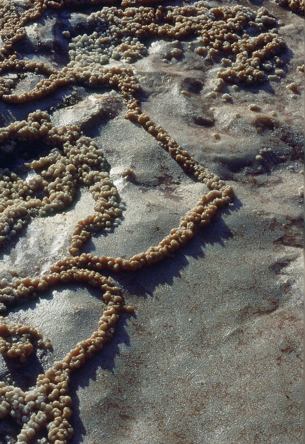
I had the Hidden World to myself, with its strange natural art on salt flats, and crystal-coated gypsum in ponds as still as glass.


At ground level, concealed beneath ledges of hard mud, dirt and gypsum, there were pockets of selenite crystals, some thick-bladed, and reddish-orange; others white, translucent, sharp enough to prick a fingertip—and so fragile they’d break at a careless touch.


Around small ponds, motionless white waves made of delicate crusts supporting interlocked filigreed formations like strands of beads, washed up against shorelines of vicous mud covered with brown selenite crystals.

There were also victims, and evidence of small deaths with crystals and chemicals already coverng the bodies: a lizard, and the skull of a bird.


I had been giving lectures and slide shows about the tideland Urban Interface wildlife to local chapters of the Sierra Club, the Audubon Society, camera clubs and the San Francisco Bay National Wildlife Refuge. Mentally, I began making notes for a new series, The World No One Knows. I wanted to share this place.
I never did.
I had reached the age where I needed to make tough decisions, one of them based on the reality that while nature photography was my passion, work that gave me peace and purpose, it would never provide a decent living. So I found a job as a real estate photographer. Every day in my job, driving on Highway 101, I passed Inner Bair—but I never went back.
Bair Island is evidence that even degraded urban environments can be renewed. The disappearance of gypsum and selenite formations, weeds, broken wood frameworks and polluted ponds covered with a mud and chemical crust was, perhaps, regrettable…or not, because what replaced them is priceless.
But in my photos, the hidden world survives. Recently, I took the slides out of storage, looked at them again on a light box, and thought, I must share these.


Comments